Geographical Capital and GIS-Supported Participatory Community Forest Resource Management : A Case Study of Ban Charat, Buachet District, Surin Province
Abstract
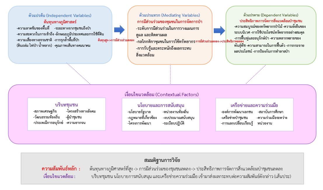
This research aims to : 1) study the geographic cost conditions in the management of community forest resources; 2) examine public participation in the management of community forest resources; and 3) propose appropriate guidelines for the development and management of community forest resources. The case study focuses on the Ban Jaras School Community Forest, Jaras Sub-district, Buachet District, Surin Province. This study employed a mixed methods research approach using a Sequential Explanatory Design, in which quantitative data were collected first, followed by qualitative data to explain the results. Quantitative data were gathered using questionnaires from a sample of 229 participants, while qualitative data were obtained through in-depth interviews with 64 stakeholders, focus group discussions with 15 participants, field observations, and spatial data analysis using Geographic Information Systems (GIS). The findings revealed that the community forest area possesses high geographic cost characteristics, including an average slope of 15 - 25 degrees, an average distance of 2.3 kilometers from the community, accessibility difficulties during the rainy season (average score 2.1), and risks from natural hazards. These factors directly affect the efficiency of resource management in the area. Nevertheless, the community has adapted and managed these limitations effectively through participatory processes (average satisfaction score 4.55), such as the establishment of conservation groups, utilization of schools as learning centers, creation of firebreaks, construction of check dams, and cultural activities such as forest ordination ceremonies. According to the community’s satisfaction survey regarding geographic costs in community forest resource management, the respondents' opinions ranged from high (average score 4.30) to the highest (average score 4.77) concerning geographic cost conditions, public participation, and management approaches. Notably, strong participation in community activities and support for conservation initiatives reflect acceptance and satisfaction with the current management models. The study recommends promoting the use of geographic information systems alongside local wisdom, encouraging participation from all sectors, and establishing collaborative networks between communities and government agencies to enhance the sustainable management of community forest resources in the long term.
Downloads
Article Details
How to Cite
Section
Research Articles
Copyright & License
Copyright (c) 2025 Arts and Culture Journal of the Lower Moon River

This work is licensed under a Creative Commons Attribution-NonCommercial-NoDerivatives 4.0 International License.
All articles published open access under the CC BY-NC-ND 4.0 license will be immediately and permanently free for everyone to read, download, copy, distribute, print, search, or link to articles free of charge. Use of the articles is permitted for non-commercial purposes only and without modifications. Access does not require prior permission from the publisher or the author, provided that the original publication is appropriately and adequately cited.


References
กรมป่าไม้ ส่วนส่งเสริมการจัดการป่าชุมชน. (2563). รายงานประจำปีการบริหารจัดการป่าชุมชน. กรมป่าไม้.กระทรวงมหาดไทย.
เดือนนภา ภู่ทอง. (2561). การจัดการทรัพยากรป่าไม้ชุมชนในยุคโลกาภิวัตน์. มหาวิทยาลัยมหิดล.
ธนวรรธน์ พลวิชัย. (2559). สถิติสำหรับการวิจัยทางสังคมศาสตร์. สำนักพิมพ์มหาวิทยาลัยหอการค้าไทย.
ประเมิน กาฬภักดี. (2564). แนวทางการจัดการทรัพยากรป่าชุมชนอย่างยั่งยืนในเขตพื้นที่ภาคตะวันออก. วารสารนิติศาสตร์และสังคมท้องถิ่น, 5(1), 1 - 27.
วนมพร พาหะนิชย์. (2568). กิจกรรมเพื่อศึกษาต้นทุนภูมิศาสตร์ ณ ป่าชุมขนโรงเรียนบ้านจรัส ตำบลจรัส อำเภอบัวเชด จังหวัดสุรินทร์ [ภาพถ่าย]. การจัดเก็บส่วนบุคคล.
วันชนะ จูบรรจง, รุ่ง หมูล้อม, มาลี ตั้งระเบียบ, และ อภิชัย ซื่อสัตย์สกุลชัย. (2568). การใช้เทคโนโลยีภูมิสารสนเทศสำหรับโครงการอนุรักษ์พันธุกรรมพืช อพ.สธ. มหาวิทยาลัยเทคโนโลยีราชมงคลล้านนา. วารสารวิชาการ มทร.สุวรรณภูมิ, 13(1), 71 - 87.
สมศักดิ์ สามัคคีธรรม. (2561). การจัดการป่าชุมชนบนพื้นฐานของการจัดการภาคีสาธารณะแบบใหม่ในภาคตะวันออก. วารสารพัฒนาสังคมและยุทธศาสตร์การบริหาร, 20(1), 41 - 56.
สาโรช แสงเมือง, พิชญ รัชฎาวงศ์, และ กฤตยาภรณ์ เจริญผล. (2566). การประยุกต์ใช้เทคโนโลยีภูมิสารสนเทศในการวิเคราะห์ความเปลี่ยนแปลงการใช้ที่ดินด้วยข้อมูลดาวเทียม. วารสารวิชาการโรงเรียนนายร้อยพระจุลจอมเกล้า, 21(1), 12 - 27.
สำนักบริหารการทะเบียน กรมการปกครอง. (2568). รายงานสถิติจำนวนประชากรประจำเดือนมกราคม 2568. https://stat.bora.dopa.go.th/stat/statnew/statMONTH/statmonth/#/mainpage.
สิทธิชน ดีแสน, วิทยา ดวงธิมา, และ นิกร มหาวัน. (2565). แนวทางการจัดการต้นทุนทางนิเวศสิ่งแวดล้อมที่เกิดจากระยะทางอาหาร กรณีศึกษา เมืองเชียงใหม่. วารสารวิชาการวิทยาลัยบริหารศาสตร์, 5(3), 63 - 81.
อดิศร ภู่สาระ. (2564). การพัฒนารูปแบบการจัดการป่าชุมชนตามพระราชบัญญัติป่าชุมชน : กรณีบ้านร่มฟ้าหลวง อำเภอเวียงแก่น จังหวัดเชียงราย. วารสารวิทยาการจัดการปริทัศน์, 23(1), 173 - 179.
Agafonkin, V. (2025). Leaflet Tutorials. Leaflet. https://leafletjs.com/examples.html.
Agrawal, A., & Chhatre, A. (2006). Explaining Success on the Commons : Community Forest Governance in the Indian Himalaya. World Development, 34(1), 149 - 166. https://doi.org/10.1016/j.worlddev.2005.07.013
Anup, K. C. (2017). Community Forestry Management and Its Role in Biodiversity Conservation in Nepal. In Lameed, G. S. A. (Eds.), Global Exposition of Wildlife Management. InTech. https://doi.org/10.5772/65926.
Banerjee, S., & Palit, D. (2023). Geospatial Techniques in Sustainable Forest Management for Ecorestoration and Different Environmental Protection Issues. In Banerjee, A., Jhariya, M. K., Bargali, S. S., & Palit, D. (Eds.), Ecorestoration for Sustainability (351 - 371). Wiley. https://doi.org/10.1002/9781119879954.ch11.
Harvey, D. (2001). Spaces of Capital : Towards a Critical Geography. Edinburgh University Press. Journal of Interdisciplinary Innovation Review, 6(5), 307 - 320.
Krejcie, R. V., & Morgan, D. W. (1970). Determining Sample Size for Research Activities. Educational and Psychological Measurement, 30(3), 607 - 610. https://doi.org/10.1177/001316447003000308.
Longley, P. A., Goodchild, M. F., Maguire, D. J., & Rhind, D. W. (2015). Geographic Information Science and Systems (4th ed.). John Wiley & Sons.
Morales-Nieves, G. M. (2022). Priorities, Perspectives, and Use of a Community Forest by Surrounding Residents in Mayagüez, Puerto Rico: Protecting the Forest for Its Services. In Montagnini, F. (Eds.), Biodiversity Islands : Strategies for Conservation in Human-Dominated Environments (20, 505 - 530). Springer International Publishing. https://doi.org/10.1007/978-3-030-92234-4_20.
Ostrom, E. (1990). Governing the Commons : The Evolution of Institutions for Collective Action. Cambridge University Press.
Zhan, F. B., & Noon, C. E. (1998). Shortest Path Algorithms : An Evaluation Using Real Road Networks. Transportation Science, 32(1), 65 - 73. https://doi.org/10.1287/trsc.32.1.65.
